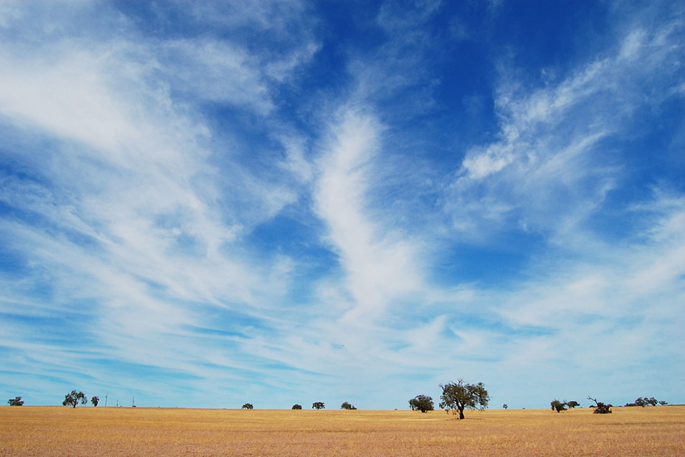
Late July 1923, Newdegate district, Western Australia. It is not a sublime landscape, but beauty may yet be found in its intricate, fragile detail. The slender trunks of the merrit mallees glow pink in the light of the rising sun. Yellow-throated miners chase noisily in the upper branches, watched keenly by a brown goshawk in a nearby salmon gum. Below, between the melaleucas, a mallee fowl scratching in the sand finds a legless lizard and devours it in two gulps. Giant ants crawl busily around sandalwood stumps and emus drink from a shallow pool on a flat granite outcrop. A rabbit pauses beside a ti-tree not yet in flower, sits upright and delicately cleans its nose with its paws, much like a cat.
As the sun rises, the aroma of wood smoke and frying bacon mingles with the subtle scent of the eucalyptus and melaleuca. Soon the noise of axe biting into wood joins the chatter of the miners, the thumping of the buck rabbits. This is a landscape already bearing the imprint of colonisation but about to undergo a more visibly dramatic transformation, as government policy and popular aspirations together mobilise an army of settlers to eat away at the “wilderness.”
Wheatbelt farms established in the twentieth century were to provide an independent living for hardworking families and grain for hungry millions, as well as wealth and respect for the state and its denizens. From around 70,000 acres in 1890, the area under crop in Western Australia had exploded to almost five million acres by 1930.
Such reckless occupation left wheatbelt families vulnerable – to prices that fell and rain that failed, to salt and locusts and boredom. The earth that remained when the bushland was consumed was also left vulnerable – to salt, erosion and abandonment. No amount of optimism, investment or technology would enable the vision of bountiful fields dotted with smiling homesteads and bustling villages to be realised in a low-nutrient environment, so far from large markets: only large-scale industrialised farming would make the wheatbelt a viable economic proposition.
After the devastation of the droughts of the 1930s, the intensification of industrial farming increased. The approach worked for a while, but its success is always provisional in these lands. Now, the industrial paradigm is facing a bleak future. Utterly dependent on fossil fuels and agrochemical inputs to grow crops and conserve the soil, while demanding ever greater economies of scale that whittle away at its social sustainability, it is not clear that the industrialised wheatbelt will survive the next century as a social and economic unit. Wheatbelt communities are trying to develop ways of living on the land that respect its fragility and work with its strengths, though they are doing so at a time when the region no longer plays a central role in the state’s imagined future, and political support has ebbed.
Today, though home to only around 135,000 people, the Western Australian wheatbelt is visible from space. Lying across the southwest corner of the continent, the light beige-green farmland eats into dark green forest to the west and blush-brown shrubland to the northeast. White chains of salt lakes and saline watercourses run like stretch marks across the lumpy and freckled skin of this old land. In one section, the division to the east is marked by a long, straight line, as if the wheatbelt had been cut out with a knife rather than nibbled away. Here, where it follows the State Barrier Fence of Western Australia (previously the “No. 1 Rabbit Proof Fence”), the line extends strikingly into the atmosphere: clouds form over the native vegetation on one side, while the sun beats down from clear skies over wheatfields on the other. Less rain now falls on the cleared land west of the fence. Consuming the bushland has had significant local climatic effects, as well as contributing to the global climate change that is increasing frosts and reducing rainfall across the region.
In 2012, the statistical region that encompasses most of the wheatbelt was home to more vehicles than people and more men than women. The population density was two-thirds of a person per square kilometre, about the same as the Yamal–Nenets Autonomous Area in the Arctic zone of western Siberia.
Yet in 2012–13, just under half of Australia’s total cereal exports came from here, including 8.5 million tonnes of wheat, most of which was sent to Indonesia, South Korea, Japan, Iraq and Iran. Western Australia is the principal source of wheat for Japanese and Korean udon noodles. On average, the annual wheat crop produced by the region is around the same as that of Italy and accounts for about 1 per cent of total global wheat production. The economic significance of wheat to Western Australia has greatly surpassed its contribution to two ideals: populating the land and world nutrition.
Just after the commencement of the rush to the Eastern Goldfields, when Western Australia was still a net importer of wheat, the West Australian Settler’s Guide and Farmer’s Handbook conveyed a clear sense of optimism about the colony’s potential: “Western Australia may be likened to a huge pie, the crust of which has only, as yet, been nibbled around the edges… We want Jack Horners here to pull out the plums, and plums there are undoubtedly for men of all avocations.” One of the most desirable commodities to be extracted from the pie was wheat – essential to the staff of life, it commanded good prices on international markets. The most desirable Jack Horners were white and of limited means: men who would not run large pastoral estates or speculate on the land, but occupy and transform it. Before the first world war, such “bona fide” settlers were enticed to become wheat farmers with cheap land, railways, credit and subsidised conditional immigration. As the gold industry began employing fewer men, the government saw the project of transforming empty wilderness into wheat farms as a solution to the state’s growing unemployment problem; later, it would be seen as a means to reward – and disperse – returned soldiers.
The region was never really an “empty” wilderness. For generations, it had been managed by Aboriginal people to provide food and other necessities. They ate from the landscape they shaped – through use of fire – without consuming it whole. At the beginning of the twentieth century, the region’s Aboriginal people were mostly living in the bush as they had for generations. They knew how to use the land to sustain themselves.
As the government-subsidised settlement continued, some Aboriginal families found employment on pastoral stations and combined station work with traditional economic and cultural activities. While the pastoral economy could accommodate many traditional Aboriginal practices, those opportunities began to evaporate as land was cleared, fenced and worked by settler families. Some were able to make a living within the new agricultural economy – clearing, fencing, pulling poison, or taking on seeding and harvesting work – and others hunted kangaroos or trapped possum for skins, or collected mallet bark for tanning. Some worked on the construction of the roads and railways that would extend their dispossession, while a few became farmers.
By the 1920s many were sent, or drawn through lack of alternatives, to reserves, missions or “native settlements” – spartan, unsympathetic institutions that further marginalised them, while maintaining them as cheap labour for the white landholders who had displaced them. In spite of the privations, many Aboriginal families sustained their amicable relationships with white settlers. They also preserved some knowledge of traditional culture and language. Increasingly, however, the experience was one of segregation and pauperisation, intensifying as the bushland that had been their succour for so long was cleared and much of the remainder, deprived of its traditional managers, became wilderness.
Clearing was hard work, but it had to be accomplished rapidly to satisfy conditional purchase requirements. Trees were ringbarked or felled, shrubs flattened with horse-drawn rollers. The lot was then burned in summer, ready for seeding in autumn. The bushland was devoured voraciously: in the eleven years from 1903 to 1914, the state’s wheat acreage increased more than tenfold to 1.4 million acres. Yet it was felt that more could be achieved.
During this period farmers began to organise politically, establishing the Country Party to oppose organised labour and secure increased support for agricultural development. Visions for the wheatbelt started to unravel as early as 1911, when drought hit the eastern and northern areas. John Payne, of Perenjori in the northern wheatbelt, remembered that when conditions worsened in 1914 his father “put his head in his hands and he cried there for a long time.” For many new farmers, crop failure one year meant a lack of money to buy seed wheat for the next. A 1934 royal commission reported that a “total abandonment of farms” took place in the Lake Brown district in 1914–16. Hoping to avert mass abandonment of farms and consequent losses on state investment, the government established the Industries Assistance Board, which propped up the wheat industry through several indifferent seasons and the severe drought of 1914, until conditions improved after the war.
The wheatbelt was never self-sustaining. Though it consumed the labour of countless families and beasts, the region would never have been created as a “wheatbelt” had it not been for the redirection of state resources to provide infrastructure for farmers to establish their enterprises, and to give support when environmental or economic conditions were less than favourable.
Throughout this period there was no clear wheat frontier; rather, land was taken up in a complex pattern determined by soils, railways, rainfall and other factors. After 1906, land for selection was mapped and classified as first-, second- or third-class according to its agricultural potential: the original classification and valuation forms held by the State Records Office show fingers of red second-class or uncoloured third-class land extending into the first-class lands shaded blue. Blocks were to contain a minimum amount of first-class land, though most included some land of each class.
Some of the forms show ominous black patches. These are the poison lands, home to the Gastrolobium and Oxylobium species that sprang up in succulent, deadly profusion, especially after land was cleared and burned. Native mammals were largely immune to the toxin in these plants, but even small amounts could readily kill sheep, cattle and horses. Such land was avoided by all but the most desperate, optimistic or well-resourced.
As the first-class land close to railways was taken up, settlers pushed out into areas many miles from railways, then lobbied and hoped that a spur line would come their way. The land itself shaped railway routes through its features of elevation and drainage, though social and political factors were also critical. Development therefore occurred over widely scattered areas, producing numerous isolated farms and small, dispersed communities. This pattern arguably increased settler vulnerability to economic and psychological hardship.
After the war, development efforts were redoubled, though by 1920 it was understood that virtually all of the first-class land with adequate rainfall and within twelve miles of a railway had been “alienated” – allocated by the government to farmers. Much of the land that remained was therefore marginal, comprised largely of “light lands,” treeless areas characterised by sandy soils that extended throughout the wheatbelt. From 1922 these lands, where accessible by rail, sold for as little as one shilling per acre, and by 1928 more than five million acres had been alienated. There was little understanding of how best to farm the light lands. New settlers who depended entirely on them were especially vulnerable to climatic and economic change, and turnover of farms was high.
By 1931, Western Australia was exporting forty-two thousand bushels (1544 tonnes) of wheat, mainly to Great Britain, but also to India, Italy, South Africa and Egypt. But the provision of cheap wheat to the Empire (and beyond) came at a high cost to both the land and the people. The folly of such optimistic development was revealed when, in the 1930s, wheat prices crashed, followed by a succession of dry seasons and plagues of rabbits, emus and wild turnip. Hundreds walked away from their properties; others were, once again, bailed out by the state.
Llewellyn Walder, previously an inspector for the Agricultural Bank, recalled of the eastern wheatbelt that “only a very few farmers remained there. The bulk of the people just walked away with whatever they could carry.” These and other outer areas were later declared marginal and reconstructed into larger farms, with a focus on stock rather than wheat. A similar conjunction of circumstances wreaked havoc in the central plains of the United States, where overworked lands became the Dust Bowl, with devastating consequences for people and the environment.
Some of the farmers who had sufficient capital and luck to survive the trials of the 1930s sought to expand and diversify their operations by more efficient exploitation of light lands. They experimented with applications of copper and zinc on sandy areas within their holdings and after the war they collaborated with agricultural scientists. In the 1940s and 50s, their findings were translated through work on government research stations and private farms to light lands elsewhere in the wheatbelt. In 1962, the Age described the light lands around Esperance as “a wasteland… until after the second world war, when science changed despair into something infinitely encouraging. Catalysts in this transformation were trace elements.”
The rhetoric here echoed that of E.F. Smart who, in 1960, produced a booklet describing the development of his 87,000-acre farm on light lands at Mingenew, entitled Western Australian Wasteland Transformed!. Premier David Brand lauded Smart for his “vigorous large-scale attack on the problem of light-land development,” while Smart himself emphasised the necessity of developing such lands, stating that otherwise “we run the risk of having it done by intruders. There are millions of people to the north of our continent who are cramped for space and opportunity, and these idle lands will beckon them unless we occupy them and make them productive.” By this time, the preference for the “small man” was waning, though whiteness was still a requirement for prospective landholders.
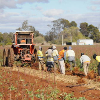
Western Australia was one of the few parts of the developed world to undertake land clearing on a massive scale after the second world war. Rapid mechanisation transformed and accelerated the consumption of the remaining wilderness. From 1946, bulldozers were used to push over and heap up trees for burning, while crawler tractors dragging logs or chains made short work of mallee and low shrubs. In one southern mallee area, a contractor using bulldozer drivers working in shifts was flattening four hundred hectares every twenty-four hours.
As before, the state government facilitated the process. It developed eleven hundred farms for returned servicemen, many in project areas on the light lands in the far south of the emerging wheatbelt. From 1958, the government offered remaining crown land in this area for sale under conditional purchase arrangements at a rate of more than a million acres a year. Many of the “new land farmers” who flocked to the cheapest agricultural land in Australia had never farmed before: Jerramungup farmer Ian Mangan recalled that “the guy who got the block next door to us actually owned a ladies dress shop in Wollongong. He arrived here with obviously no experience whatsoever.” The prospect of development on an even larger scale also roused that peculiarly Western Australian enthusiasm for development agreements between the state and big business.
The government entered into such an agreement with the Chase Syndicate, an American group that included high-profile celebrities such as film star Robert Cummings and TV personality Art Linkletter, to develop around 600,000 hectares of sand plains near remote Esperance. The government was to classify and survey blocks and build access roads, as well as an abattoir and fertiliser factory, while the syndicate was to develop half of the planned 650 new farms to production stage and sell half of them within fifteen years.
The syndicate soon failed, partly because of faulty clearing and sowing methods, and the agreement was renegotiated with the Esperance Land and Development Company, a joint Australian–American venture that was to develop a total of 1.4 million acres. In both the United States and Australia, this was an era of high modernist agriculture, characterised by a preference for large, planned projects that could – at least in theory – be conducted as technical exercises.
The environment was imagined as uniform, and made as close to the ideal as possible through large-scale clearing and implementation of international industrialised farming practices involving mechanisation, monoculture and massive scale. However, these practices could not transcend the messy reality of salt, dust and drought.
In 1949, there were 6.48 million hectares of cleared land on farms; by 1969 the cleared area had more than doubled to 13.77 million hectares. While economic and climatic conditions were favourable, farming proceeded apace. But from 1969, drought and a glut of wheat on international markets, which led to the introduction of wheat quotas, together brought land releases to an abrupt halt. Farmers across the wheatbelt, especially in the newly established areas, struggled throughout the 1970s: the pie turned out to be too salty, too dry, and Jack Horner’s wheat bags were difficult to sell.
Another period of consolidation followed, in which many marginal farms were bought up by bigger neighbours. Government assistance was again forthcoming, though in a more limited form than in previous harsh times. Drought-relief loans were made available, exceeding $25 million in the wake of the 1976–78 drought. Yet the staunchly pro-development coalition government of Charles Court was not deterred from further expanding the wheatbelt, announcing in 1980 that three million hectares of land would be released for agriculture in the far south coast area around Ravensthorpe.
It took until 1984 for the newly elected Labor government to declare a moratorium on further mass land releases, and another two decades before land clearing would be effectively regulated. In that time, numerous Landcare and natural resource management groups, along with individual farmers, began to ameliorate the damage by commencing revegetation projects.
Faced with growing economic pressures as well as problems of salinity, erosion and other forms of land degradation, wheatbelt farmers increasingly looked for ways to maintain efficient production while conserving the soil. Some turned to oil mallees for biofuel to diversify farm income and reduce wind erosion and salinity; by 2013, over thirty million trees had been planted across the state, many in the wheatbelt. Construction of an integrated mallee processing plant that would produce eucalyptus oil, activated charcoal and heat for electricity generation was completed at Narrogin in 2006, but closed in 2011. With little political will to develop the industry, farmers were left with trees but no market for them.
Another popular strategy was minimum tillage farming, which protected the soil from erosion while reducing the costs associated with frequent cultivation. The development of herbicides during the second world war provided an alternative to ploughing in preparation for seeding. New technologies enabling single-pass seeding were also developed, some locally. On his wheatbelt farm in 1974, Ray Harrington and his brother David worked on developing hardened knifepoints that could be used to seed directly into crop stubble, to reduce soil disturbance and compaction.
Recalling their efforts to devise a system for cultivating only the soil under the seed rows, Ray said, “We knew we needed to try something different and tried to think what we would like if we were crop seeds, deciding that would be a nice environment underneath for the young roots to grow into.” A few more farmers began to experiment with minimum tillage in the 1980s. By 1995, one-in-ten Western Australian grain growers were using these practices and as many as 35 per cent in south coastal light lands. In conserving soil moisture, minimum tillage proved more drought-resistant than conventional tillage and so enabled farming to continue in areas subject to declining rainfall – including the South West of Western Australia. But these systems are now being undermined by herbicide-resistant weeds, and scientists and farmers are again seeking solutions to the problem of how to use the soil without consuming it.
Some wheatbelt communities are looking beyond agriculture, turning, for example, to tourism and the arts to diversify and reinvigorate local economies. In 1992, with only thirty-five children enrolled at the local school and businesses struggling, the eastern wheatbelt town of Hyden was in decline; seven years later, however, there were sixty-five students and around twenty new businesses. The key to this revitalisation was community action to establish partnerships with government and invest in diversification. The region’s grain, beef and wool farmers put forward the funds to construct a hotel, motel and caravan park to service visitors to local attractions, such as the impressive geological formation known as Wave Rock.
By 1999, tourism was bringing $5 million a year into Hyden and employing sixty local people, though sheep and cattle production remained the mainstay of the local economy. A Hyden Business Development Company, established with seed funding from local farmers, enabled new businesses in the area – plumbers, auto electricians and metal fabricators – to start up with subsidised rentals and community loans for equipment. The town now also boasts a telecentre, retirement village and youth housing, and hosts a popular annual rock music festival, the Wave Rock Weekender.
Lake Grace has undergone a similar transformation, including the establishment of the Regional Artspace, which supports a flourishing arts community and connects the town with the wider state and national arts scenes. These towns are fortunate to have had the capacity to invest in their future: not all wheatbelt settlements are so placed.
While the wheatbelt was established, and sometimes sustained, on the back of government largesse, in the wake of a more neoliberal policy orientation communities are having to compete for government funds to supplement the self-funding of projects intended to achieve diversification for social and economic sustainability.
From 2008, the National Party held the balance of power in the Western Australian parliament and used its position to implement its “Royalties for Regions” policy, by which a quarter of the state’s mining and petroleum royalty payments were to be spent on projects and initiatives in regional areas. Under the scheme, communities apply for funding in a competitive process. Premier Colin Barnett described the program as “outstanding” and claimed that “no government in Australian history had such a dramatic and direct effect on regional communities.”
In every competition there are winners and losers. A June 2014 report found that many funded projects were not required to demonstrate long-term sustainability, and evaluations were focused on the infrastructure and services delivered rather than the achievement of intended long-term outcomes. The contribution of this program to wheatbelt sustainability is at present unclear.
In 2014, the Aboriginal people of the wheatbelt remained in a disadvantaged position, though many hope that ongoing negotiations with the state government, aimed at resolving native title claims over the greater southwest, will provide legal recognition of their status as traditional owners of the land and provide ongoing support for Aboriginal economic development in the region.
The “wilderness” that is now the wheatbelt was eaten as the result of an inappropriate vision for the region. This vision motivated a small army of prospective farmers and resourced them to cut, burn, plough and sow until the land, and indeed the climate, had been transformed. Through technological ingenuity and consolidation of business operations, and with considerable state aid, farming has evolved in response to environmental and economic challenges in a way that has enabled us to keep eating the wilderness. The government gave the wheatbelt its start and bailed it out whenever it was in trouble; for Western Australia, it was too big to fail. Now, when the problems it faces are greater than ever, political support is precarious.
In the twenty-first century, as many wheatbelt communities struggle to protect their integrity and sustainability, the food produced by the region is becoming a critical global resource. The question is whether communities have sufficient capacity to transition to more sustainable production models and develop the social sustainability required to address the challenges ahead, or whether the future, along with the wilderness, has already been consumed. •
This essay appears in Griffith Review 47: Looking West, where a fully referenced version is available.